Day 31
August 31, rainy morning in Holyhead. I had some plans for a productive day, as it might be my last day here. I was determined to face the rain and visit some places of my interest here, mainly the Parys Mountain, a copper mine close to Amlwch. But again I was not fortunate as today is some kind of bank holyday (no one could explain me exactly what is it), so like the day before, there would be limited bus services and most of the places would be closed. The idea of another day like the day before was not much appealing to me.

 holyhead, bank holyday humdrum
HOLYHEAD
So I decided visit some sites close to Holyhead that I had missed, or just left for a day like today. One of them is a major feature, the Trefignath burial chamber, and the other, quite close is a standing stone called Ty Mawr, not far from there. As the weather was hard, I took my umbrella and bought a new bag and shoes in an open store. The soles of my shoes were getting thinner and thinner as the time passed, and started to soak up at any rain, and that was making me mad. There’s nothing worse than cold wet feet in rainy days. So far I had to buy an umbrella, new shoes, new bag and new coat because of the rain. That’s English Summer. Everything I wear smells and are wet most of the time. I am not someone about to complain, but in days like that feels sorry for yourself.
After my new improvements, I just went on and as the sites were around one mile of the town, I could find the right road with no mistake. The first I’ve found was the standing stone. It was 9 feet high, in the fashion of the others I’ve seen around, thin on the side and wide in the front. Ty Mawr is in the Anglesey Aluminum state, so in one way, it was well kept, and the access was easy. It seems that all the surrounds belong to them.
STANDING STONE
The standing stones are mainly more recent than the burial chambers and their meaning are quite unclear. They just stand in the landscape and like the stone circles don’t say much of their meaning. Some try to find astronomical alignments to the stone circles, but the standing stones can’t tell this story.
They can be very significant in the Ley lines theory, as they spot the landscape very precisely, and can be a mark in a pathway or old road. Or like in the Nordic tradition, they can be erected in homage of an important person, but there’s no hint of this anyway.


standind stone
TREFIGNATH BURIAL CHAMBER

 getting close to the chamber
The Trefignath burial chamber is a very special one. It is composed from three distinct phases of occupation. It must have been covered in stones, but today there is no much of this old feature. The group dates from around 3000 BC, based on the remains of pottery found by the excavations made in 1978 and 1979 in the older chamber. The other two must be some centuries later.
 three entrances to the chambers, distinguished in time

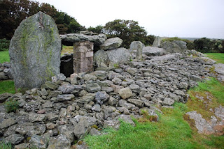 this is the phase III of occupation, and the most beautiful

From the second phase, it is possible to recognize the entrance, but today in bad shape, as it had fall down. It clearly had a capstone and side slabs. The best preserved and more interesting is the third phase tomb. It has the double feature of the Plas Newydd, and entrance with lateral slabs. In Plas Newidd it would lack both the entrance slabs as the more integrated assemble of Trefignath. This kind of entrance is said to be found in south Scotland, and adds depth to the entrance.
Trefignath seems to comprise several traditions in the same place, although used in different periods of time.

 the first occupation
 ...and the second phase
STONE AND GRASS


STANDING STONE
After that, I still tried to go after other Standing Stone that should not be so far, and that I possibly could reach walking. On the side of the road I still found a third standing stone not signed in my Ordenance Survey. This was less significant than Ty Mawr but no less interesting to me. It had some 1.50 meter high (5 feet), and stand in the top of a little mound. I just had the time to see it and go back to the road when the rain got me really hard. I had to take my umbrella, find a shelter and wait for some 30 minute until it was possible to go back to town (because at that point I lost any interest in go on). My umbrella got into pieces by the wind, it was very unpleasant situation. After that I decided for a light day back to Holyhead, packing for traveling tomorrow. Going to Ireland or go back London, I still don’t made my mind.
Should I stay or should I go?


 I left here my broken umbrellas


